
Thank you for supporting this site ❤️
Make a donation
Make a donation
Gear up for your next adventure:
As an Amazon Associate, this site earns from qualifying purchases at no extra cost to you.
Janitzio topographic map
Click on the map to display elevation.
Thank you for supporting this site ❤️
Make a donation
Make a donation
Gear up for your next adventure:
As an Amazon Associate, this site earns from qualifying purchases at no extra cost to you.
About this map
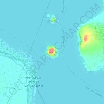
Name: Janitzio topographic map, elevation, terrain.
Location: Janitzio, Pátzcuaro, Michoacán, 61630, Mexico (19.55410 -101.67167 19.59410 -101.63167)
Average elevation: 6,693 ft
Minimum elevation: 6,670 ft
Maximum elevation: 6,936 ft
Thank you for supporting this site ❤️
Make a donation
Make a donation
Gear up for your next adventure:
As an Amazon Associate, this site earns from qualifying purchases at no extra cost to you.