
Taourga topographic map
Interactive map
Click on the map to display elevation.
About this map
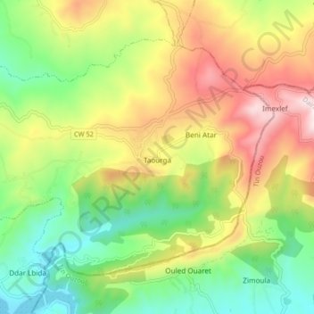
Name: Taourga topographic map, elevation, terrain.
Location: Taourga, Daïra Baghlia, Boumerdès, Algérie (36.76942 3.89856 36.81884 3.98046)
Average elevation: 1,129 ft
Minimum elevation: 89 ft
Maximum elevation: 2,562 ft
Le relief de la commune est assez montagneux, l'altitude varie entre 300 m et 700 m. À 15 km au Nord, se trouve la ville de Dellys bordant la mer Méditerranée.
Other topographic maps
Click on a map to view its topography, its elevation and its terrain.
Baghlia
Algérie > Boumerdès > Daïra Baghlia
Baghlia, Daïra Baghlia, Boumerdès, 35055, Algérie
Average elevation: 499 ft
Sidi Daoud
Algérie > Boumerdès > Daïra Baghlia
Sidi Daoud, Daïra Baghlia, Boumerdès, Algérie
Average elevation: 456 ft