
Make a donation
Gear up for your next adventure:
As an Amazon Associate, this site earns from qualifying purchases at no extra cost to you.
Perímetro Urbano Neiva topographic map
Click on the map to display elevation.
Make a donation
Gear up for your next adventure:
As an Amazon Associate, this site earns from qualifying purchases at no extra cost to you.
Perímetro Urbano Neiva
Due to its location near the equator and its low altitude, the city has a hot annual average climate with daytime temperatures ranging from 88 to 95 degrees Fahrenheit. It is about 300 kilometers / 186.4 miles (about a five-hour drive) from the Colombian capital, Bogotá.
Make a donation
Gear up for your next adventure:
As an Amazon Associate, this site earns from qualifying purchases at no extra cost to you.
About this map
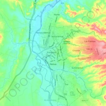
Name: Perímetro Urbano Neiva topographic map, elevation, terrain.
Average elevation: 1,539 ft
Minimum elevation: 1,375 ft
Maximum elevation: 1,936 ft
Make a donation
Gear up for your next adventure:
As an Amazon Associate, this site earns from qualifying purchases at no extra cost to you.
Other topographic maps
Click on a map to view its topography, its elevation and its terrain.