Geolocate

Calbayog topographic map

Click on the map to display elevation.

About this map

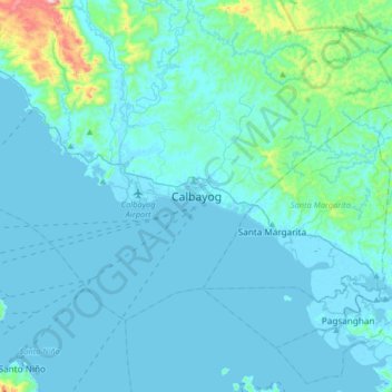
Name: Calbayog topographic map, elevation, terrain.

Location: Calbayog, Samar, Eastern Visayas, Philippines (11.90698 124.43464 12.22698 124.75464)

Average elevation: 180 ft

Minimum elevation: -7 ft

Maximum elevation: 2,182 ft

Other topographic maps

Click on a map to view its topography, its elevation and its terrain.

Guyam Island

Philippines > Samar > Catbalogan

Average elevation: 0 ft

Hamlayan

Philippines > Samar > Ulayan

Average elevation: 20 ft

Gandara

Philippines > Samar

Average elevation: 413 ft

Suribao River

Philippines > Samar

Average elevation: 879 ft

Santa Margarita

Philippines > Samar

Average elevation: 135 ft

Ulot River

Philippines > Samar > Balagon

Average elevation: 344 ft

Gear up for your next adventure:

🔦Powerful Headlamps - Ultra-bright hands-free lighting for night navigation
🥩Freeze-Dried Meals - Nutritious and lightweight food for remote expeditions
🧯Emergency Survival Kit - All‑in‑one survival essentials for the backcountry
🛏️Cold Weather Sleeping Bag - Warm sleeping bag for cold conditions
🧺Microfiber Travel Towels - Compact and fast-drying towels for trail use

As an Amazon Associate, this site earns from qualifying purchases at no extra cost to you.