
Thank you for supporting this site ❤️
Make a donation
Make a donation
Gear up for your next adventure:
As an Amazon Associate, this site earns from qualifying purchases at no extra cost to you.
Oukaïmeden topographic map
Click on the map to display elevation.
Thank you for supporting this site ❤️
Make a donation
Make a donation
Gear up for your next adventure:
As an Amazon Associate, this site earns from qualifying purchases at no extra cost to you.
Oukaïmeden
The skiing area is at an altitude of between 2,600 metres (8,500 ft) and 3,200 metres (10,500 ft) and has six ski lifts. There are some hotels and ski rental facilities nearby.
Thank you for supporting this site ❤️
Make a donation
Make a donation
Gear up for your next adventure:
As an Amazon Associate, this site earns from qualifying purchases at no extra cost to you.
About this map
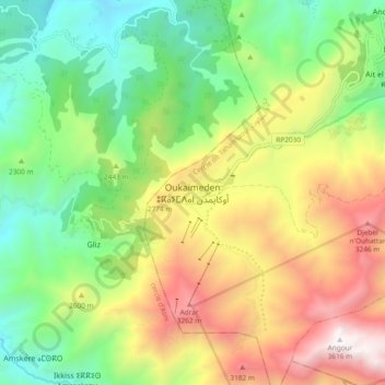
Name: Oukaïmeden topographic map, elevation, terrain.
Average elevation: 7,946 ft
Minimum elevation: 5,315 ft
Maximum elevation: 11,831 ft
Thank you for supporting this site ❤️
Make a donation
Make a donation
Gear up for your next adventure:
As an Amazon Associate, this site earns from qualifying purchases at no extra cost to you.