
Make a donation
Gear up for your next adventure:
As an Amazon Associate, this site earns from qualifying purchases at no extra cost to you.
Tysons topographic map
Click on the map to display elevation.
Make a donation
Gear up for your next adventure:
As an Amazon Associate, this site earns from qualifying purchases at no extra cost to you.
Tysons
Tysons is located at 38°55′7″N 77°13′47″W / 38.91861°N 77.22972°W / 38.91861; -77.22972 (38.918485, −77.229833) at an elevation of 486 feet (148 m). Located in Northern Virginia at the intersection of Virginia State Route 123 and State Route 7, Tysons is 11 miles (18 km) west of downtown Washington, D.C. and 6 miles (9.7 km) northeast of Fairfax, the county seat.
Make a donation
Gear up for your next adventure:
As an Amazon Associate, this site earns from qualifying purchases at no extra cost to you.
About this map
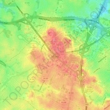
Name: Tysons topographic map, elevation, terrain.
Location: Tysons, Fairfax County, Virginia, 22103, United States (38.90340 -77.25444 38.93493 -77.19624)
Average elevation: 404 ft
Minimum elevation: 246 ft
Maximum elevation: 538 ft
Fairfax County trails, hiking, mountain biking, running and outdoor activities
Make a donation
Gear up for your next adventure:
As an Amazon Associate, this site earns from qualifying purchases at no extra cost to you.