
Lobelville topographic map
Interactive map
Click on the map to display elevation.
About this map
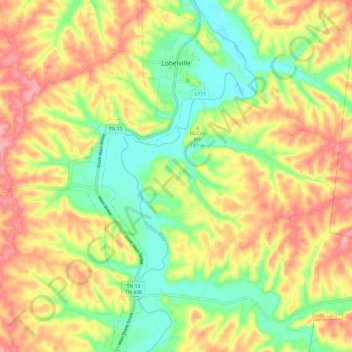
Name: Lobelville topographic map, elevation, terrain.
Location: Lobelville, Perry County, Tennessee, United States (35.69381 -87.82010 35.78898 -87.77057)
Average elevation: 604 ft
Minimum elevation: 407 ft
Maximum elevation: 814 ft
Other topographic maps
Click on a map to view its topography, its elevation and its terrain.
Linden
United States > Tennessee > Perry County
Linden, Perry County, Middle Tennessee, Tennessee, 37096, United States
Average elevation: 568 ft
Pine View
United States > Tennessee > Perry County > Pine View
Pine View, Perry County, Tennessee, United States
Average elevation: 525 ft