
Sur Les Bois topographic map
Interactive map
Click on the map to display elevation.
About this map
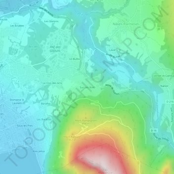
Name: Sur Les Bois topographic map, elevation, terrain.
Average elevation: 2,070 ft
Minimum elevation: 1,463 ft
Maximum elevation: 4,157 ft
Other topographic maps
Click on a map to view its topography, its elevation and its terrain.
Seynod
France > Auvergne-Rhône-Alpes > Haute-Savoie > Annecy
Seynod, Annecy, Haute-Savoie, Auvergne-Rhône-Alpes, France métropolitaine, 74600, France
Average elevation: 2,136 ft