
Make a donation
Gear up for your next adventure:
As an Amazon Associate, this site earns from qualifying purchases at no extra cost to you.
Brno topographic map
Click on the map to display elevation.
Make a donation
Gear up for your next adventure:
As an Amazon Associate, this site earns from qualifying purchases at no extra cost to you.
Brno
The city is relatively low-lying, with elevations ranging between 190 m (623 ft) and 497 m (1,631 ft). The highest peak within the municipal area is Kopeček Hill, at 479 m (1,572 ft), and the highest elevation overall is Útěchov, located on the border with Vranov. Brno is located within the Danube basin. The length of the Svratka River waterway through the city is about 29 km (18 mi), and the Svitava River's waterway is about 13 km (8 mi). Several smaller streams flow through Brno, including the Veverka Creek [cs], the Ponávka [cs], and the Říčka [cs]. Of note is the Brno Reservoir, as well as numerous ponds, and other standing bodies of water, such as the reservoirs in the Marian Valley [cs] and the fishpond Žebětínský rybník [cs].
Make a donation
Gear up for your next adventure:
As an Amazon Associate, this site earns from qualifying purchases at no extra cost to you.
About this map
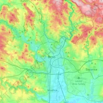
Name: Brno topographic map, elevation, terrain.
Average elevation: 971 ft
Minimum elevation: 610 ft
Maximum elevation: 1,742 ft
Make a donation
Gear up for your next adventure:
As an Amazon Associate, this site earns from qualifying purchases at no extra cost to you.
Other topographic maps
Click on a map to view its topography, its elevation and its terrain.