
Laurensberg topographic map
Interactive map
Click on the map to display elevation.
About this map
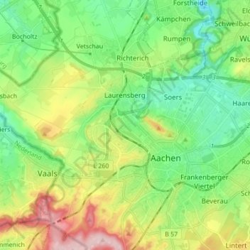
Name: Laurensberg topographic map, elevation, terrain.
Average elevation: 653 ft
Minimum elevation: 400 ft
Maximum elevation: 1,138 ft
Other topographic maps
Click on a map to view its topography, its elevation and its terrain.
Scherpenberg
Germany > North Rhine-Westphalia > Städteregion Aachen > Aachen
Scherpenberg, Aachen, Städteregion Aachen, North Rhine-Westphalia, 52074, Germany
Average elevation: 843 ft