Geolocate

Bagasbas topographic map

Click on the map to display elevation.

About this map

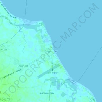
Name: Bagasbas topographic map, elevation, terrain.

Location: Bagasbas, Camarines Norte, Bicol Region, 4600, Philippines (14.11731 122.96161 14.15731 123.00161)

Average elevation: 3 ft

Minimum elevation: 0 ft

Maximum elevation: 26 ft

Other topographic maps

Click on a map to view its topography, its elevation and its terrain.

Daet River

Philippines > Camarines Norte > Daet > Bibirao

Average elevation: 62 ft

Daet River

Philippines > Camarines Norte > Daet

Average elevation: 10 ft

Bagasbas Beach

Philippines > Camarines Norte > Daet

Average elevation: 3 ft

Vinzons

Philippines > Camarines Norte

Average elevation: 33 ft

Paracale

Philippines > Camarines Norte

Average elevation: 36 ft

Gear up for your next adventure:

🪶Survival Guide Book - Expert advice for emergency preparedness
🔦Powerful Headlamps - Ultra-bright hands-free lighting for night navigation
🛰️Satellite Messengers - Emergency SOS and two-way messaging for off-grid adventures
🩹Survival Bandages - High‑quality bandages for emergencies
🎒Hydration Pack - Hands‑free water reservoir for long hikes

As an Amazon Associate, this site earns from qualifying purchases at no extra cost to you.