
Mangualde topographic map
Interactive map
Click on the map to display elevation.
About this map
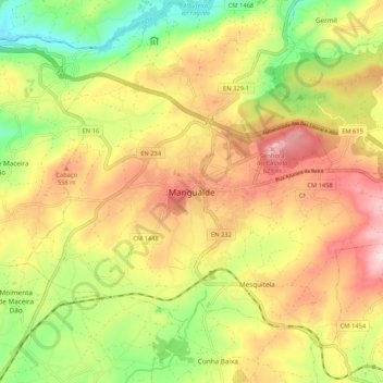
Name: Mangualde topographic map, elevation, terrain.
Location: Mangualde, Viseu, Viseu Dão-Lafões, Centro, 3530-206, Portugal (40.56354 -7.80560 40.64354 -7.72560)
Average elevation: 1,529 ft
Minimum elevation: 925 ft
Maximum elevation: 2,129 ft
Other topographic maps
Click on a map to view its topography, its elevation and its terrain.
Contenças de Cima
Portugal > Centro > Mangualde > Santiago de Cassurrães > Contenças de Cima
Contenças de Cima, Santiago de Cassurrães, Santiago de Cassurrães e Póvoa de Cervães, Mangualde, Viseu, Viseu Dão-Lafões, Centro, 3530-051, Portugal
Average elevation: 1,407 ft