
Meta topographic map
Interactive map
Click on the map to display elevation.
About this map
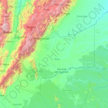
Name: Meta topographic map, elevation, terrain.
Location: Meta, Colombia (0.94001 -75.56001 6.06001 -70.44001)
Average elevation: 2,270 ft
Minimum elevation: 341 ft
Maximum elevation: 17,169 ft
Other topographic maps
Click on a map to view its topography, its elevation and its terrain.
Caño Cristales
Colombia > Meta > La Macarena
Caño Cristales, La Macarena, Ariari, Meta, RAP (Especial) Central, Colombia
Average elevation: 951 ft