
Make a donation
Gear up for your next adventure:
As an Amazon Associate, this site earns from qualifying purchases at no extra cost to you.
Province of Asunción topographic map
Click on the map to display elevation.
Make a donation
Gear up for your next adventure:
As an Amazon Associate, this site earns from qualifying purchases at no extra cost to you.
Province of Asunción
The province consists sloping land that are part of the Andean flanks delimiting with other provinces and are of rugged topography, the soils are moderately deep to shallow, medium to low fertility, with both coarse fragments in the profile and on the surface thereof, are highly erodible. The normal topography is undulating, of slopes ranging from gentle to steep in some areas (especially in the upper parts of Chacas) has plenty of stones on the surface and are of variable shape. The soils are of residual-colluvial parent material which are igneous rocks; grained diorite and shale. Within the area are three different physiographic landscapes: rivers, hills and mountains, the same that characterize the Asunción Province.
Make a donation
Gear up for your next adventure:
As an Amazon Associate, this site earns from qualifying purchases at no extra cost to you.
About this map
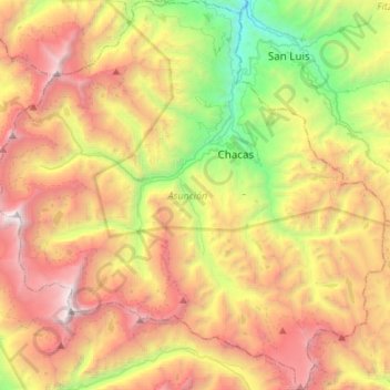
Name: Province of Asunción topographic map, elevation, terrain.
Location: Province of Asunción, Ancash, Peru (-9.32411 -77.53355 -9.05679 -77.26205)
Average elevation: 13,990 ft
Minimum elevation: 8,563 ft
Maximum elevation: 20,167 ft
Make a donation
Gear up for your next adventure:
As an Amazon Associate, this site earns from qualifying purchases at no extra cost to you.