
Thank you for supporting this site ❤️
Make a donation
Make a donation
Gear up for your next adventure:
As an Amazon Associate, this site earns from qualifying purchases at no extra cost to you.
Lüneburg topographic map
Click on the map to display elevation.
Thank you for supporting this site ❤️
Make a donation
Make a donation
Gear up for your next adventure:
As an Amazon Associate, this site earns from qualifying purchases at no extra cost to you.
About this map
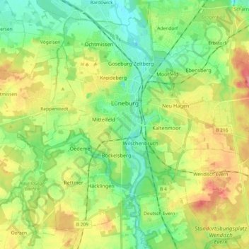
Name: Lüneburg topographic map, elevation, terrain.
Location: Lüneburg, Landkreis Lüneburg, Lower Saxony, Germany (53.19164 10.33100 53.28648 10.51438)
Average elevation: 115 ft
Minimum elevation: 16 ft
Maximum elevation: 269 ft
Thank you for supporting this site ❤️
Make a donation
Make a donation
Gear up for your next adventure:
As an Amazon Associate, this site earns from qualifying purchases at no extra cost to you.