
El Romeral topographic map
Interactive map
Click on the map to display elevation.
About this map
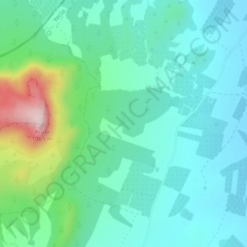
Name: El Romeral topographic map, elevation, terrain.
Location: El Romeral, Yecla, Altiplano, Región de Murcia, España (38.68737 -1.28137 38.70737 -1.26137)
Average elevation: 2,566 ft
Minimum elevation: 2,316 ft
Maximum elevation: 3,432 ft
Other topographic maps
Click on a map to view its topography, its elevation and its terrain.
Rambla de Jumilla
España > Región de Murcia > Yecla
Rambla de Jumilla, Yecla, Altiplano, Región de Murcia, España
Average elevation: 2,484 ft