
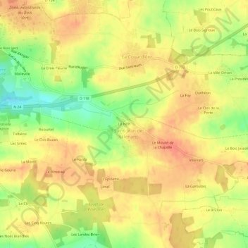
Le Nolf topographic map
Interactive map
Click on the map to display elevation.
About this map
Name: Le Nolf topographic map, elevation, terrain.
Average elevation: 295 ft
Minimum elevation: 187 ft
Maximum elevation: 358 ft
Other topographic maps
Click on a map to view its topography, its elevation and its terrain.
Le Bois Josselin
France > Bretagne > Morbihan > Ploërmel
Le Bois Josselin, Ploërmel, Pontivy, Morbihan, Bretagne, France métropolitaine, 56800, France
Average elevation: 289 ft
La Grange Neuve
France > Bretagne > Morbihan > Ploërmel
La Grange Neuve, Ploërmel, Pontivy, Morbihan, Bretagne, France métropolitaine, 56800, France
Average elevation: 240 ft
Le Clos Hazel
France > Bretagne > Morbihan > Ploërmel
Le Clos Hazel, Ploërmel, Pontivy, Morbihan, Bretagne, France métropolitaine, 56800, France
Average elevation: 194 ft
La Croix aux Loups
France > Bretagne > Morbihan > Ploërmel
La Croix aux Loups, Ploërmel, Pontivy, Morbihan, Bretagne, France métropolitaine, 56800, France
Average elevation: 190 ft
Le Champ des Oiseaux
France > Bretagne > Morbihan > Ploërmel
Le Champ des Oiseaux, Ploërmel, Pontivy, Morbihan, Bretagne, France métropolitaine, 56800, France
Average elevation: 184 ft