
Make a donation
Gear up for your next adventure:
As an Amazon Associate, this site earns from qualifying purchases at no extra cost to you.
Torreys Peak topographic map
Click on the map to display elevation.
Make a donation
Gear up for your next adventure:
As an Amazon Associate, this site earns from qualifying purchases at no extra cost to you.
Torreys Peak
The third trail starts at Loveland Pass about 4.5 miles (7.2 km) to the northwest. To reach Loveland Pass, follow I-70 west from Denver 55 miles (89 km) to where US Route 6 breaks off and heads south. Follow the meandering Route 6 approximately seven miles to the trailhead at Loveland Pass, at an elevation of 11,990 feet (3,650 m). The steepest part of the trail actually begins right away with a half mile climb of 1,000 feet (300 m). The trail follows the Continental Divide gently taking the climber down into three saddles and up two more peaks, including Grizzly Peak at 13,427 feet (4,093 m) and Mount Sniktau at 13,234 feet (4,034 m). The final saddle rests at approximately 12,600 ft. From this saddle, it is a mile-long ascent of 1,800 feet (550 m) to the final summit.
Make a donation
Gear up for your next adventure:
As an Amazon Associate, this site earns from qualifying purchases at no extra cost to you.
About this map
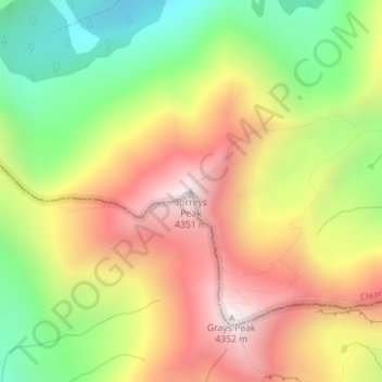
Name: Torreys Peak topographic map, elevation, terrain.
Location: Torreys Peak, Clear Creek County, Colorado, United States (39.64272 -105.82128 39.64282 -105.82118)
Average elevation: 12,644 ft
Minimum elevation: 11,040 ft
Maximum elevation: 14,242 ft
Clear Creek County trails, hiking, mountain biking, running and outdoor activities
Make a donation
Gear up for your next adventure:
As an Amazon Associate, this site earns from qualifying purchases at no extra cost to you.
Other topographic maps
Click on a map to view its topography, its elevation and its terrain.
Georgetown
United States > Colorado > Clear Creek County
The town sits at an elevation of 8,530 feet (2,600 m) above sea level, nestled in the mountains near the upper end of the valley of Clear Creek in the mountains west of Denver along Interstate 70. Although population was only about 1,000 at the 2010 census, the town was a historic center of the mining industry…
Average elevation: 9,757 ft
Make a donation
Gear up for your next adventure:
As an Amazon Associate, this site earns from qualifying purchases at no extra cost to you.
Make a donation
Gear up for your next adventure:
As an Amazon Associate, this site earns from qualifying purchases at no extra cost to you.
Georgetown
United States > Colorado > Clear Creek County
The town sits at an elevation of 8,530 feet (2,600 m) above sea level, nestled in the mountains near the upper end of the valley of Clear Creek in the mountains west of Denver along Interstate 70. Although population was only about 1,000 at the 2010 census, the town was a historic center of the mining industry…
Average elevation: 9,757 ft