
Make a donation
Gear up for your next adventure:
As an Amazon Associate, this site earns from qualifying purchases at no extra cost to you.
Nérac topographic map
Click on the map to display elevation.
Make a donation
Gear up for your next adventure:
As an Amazon Associate, this site earns from qualifying purchases at no extra cost to you.
About this map
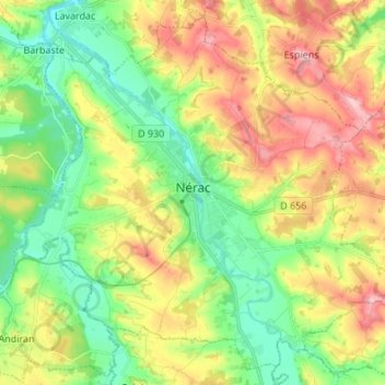
Name: Nérac topographic map, elevation, terrain.
Average elevation: 338 ft
Minimum elevation: 121 ft
Maximum elevation: 646 ft
Make a donation
Gear up for your next adventure:
As an Amazon Associate, this site earns from qualifying purchases at no extra cost to you.
Other topographic maps
Click on a map to view its topography, its elevation and its terrain.
Château de Dolmayrac
France > Nouvelle-Aquitaine > Lot-et-Garonne > Dolmayrac
Average elevation: 420 ft
Make a donation
Gear up for your next adventure:
As an Amazon Associate, this site earns from qualifying purchases at no extra cost to you.
Bissières
France > Nouvelle-Aquitaine > Lot-et-Garonne > Sainte-Colombe-de-Villeneuve
Average elevation: 528 ft