
Make a donation
Gear up for your next adventure:
As an Amazon Associate, this site earns from qualifying purchases at no extra cost to you.
Adama topographic map
Click on the map to display elevation.
Make a donation
Gear up for your next adventure:
As an Amazon Associate, this site earns from qualifying purchases at no extra cost to you.
Adama
Adama (Oromo: Adaamaa or Hadaamaa, Amharic: አዳማ), formerly Nazreth (Amharic: ናዝሬት), is a city in central Oromia Region, Ethiopia. Adama forms a Special Zone of Oromia and is surrounded by East Shewa Zone. It is located at 8°32′N 39°16′E / 8.54°N 39.27°E / 8.54; 39.27 at an elevation of 1712 meters, 99 km southeast of Ethiopian capital, Addis Ababa. The city sits between the base of an escarpment to the west, and the Great Rift Valley to the east.
Make a donation
Gear up for your next adventure:
As an Amazon Associate, this site earns from qualifying purchases at no extra cost to you.
About this map
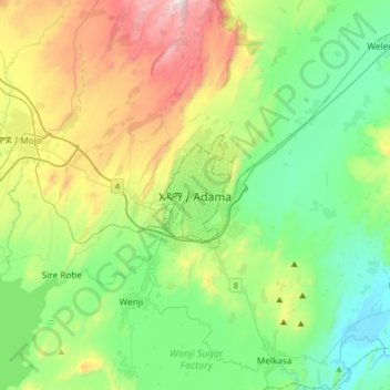
Name: Adama topographic map, elevation, terrain.
Location: Adama, Adama Special Zone, Oromia Region, 36, Ethiopia (8.38103 39.11055 8.70103 39.43055)
Average elevation: 5,489 ft
Minimum elevation: 4,396 ft
Maximum elevation: 8,028 ft
Make a donation
Gear up for your next adventure:
As an Amazon Associate, this site earns from qualifying purchases at no extra cost to you.