
Potton topographic map
Interactive map
Click on the map to display elevation.
About this map
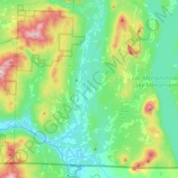
Name: Potton topographic map, elevation, terrain.
Location: Potton, Memphrémagog, Estrie, Quebec, J0E 1X0, Canada (45.00379 -72.48507 45.15767 -72.24016)
Average elevation: 1,053 ft
Minimum elevation: 495 ft
Maximum elevation: 2,690 ft
Other topographic maps
Click on a map to view its topography, its elevation and its terrain.
Mansonville
Canada > Quebec > Memphrémagog > Potton
Mansonville, Potton, Memphrémagog, Estrie, Quebec, J0E 1X0, Canada
Average elevation: 692 ft
Magog
Canada > Quebec > Memphrémagog
Magog, Memphrémagog, Estrie, Quebec, Canada
Average elevation: 820 ft
Hatley
Canada > Quebec > Memphrémagog > Hatley
Hatley, Memphrémagog, Estrie, Quebec, Canada
Average elevation: 965 ft