Geolocate

Beaver topographic map

Click on the map to display elevation.

About this map

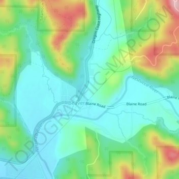
Name: Beaver topographic map, elevation, terrain.

Location: Beaver, Tillamook County, Oregon, United States (45.27121 -123.83470 45.28681 -123.81454)

Average elevation: 253 ft

Minimum elevation: 52 ft

Maximum elevation: 719 ft

Tillamook County trails, hiking, mountain biking, running and outdoor activities

Gear up for your next adventure:

😴Insulated Sleeping Pads - Compact and warm pads for high-elevation camping
☀️Outdoor Sunscreen - High protection sunscreen for outdoor activities
🧭Orienteering Set - Complete compass and map reading kit
🪵Folding Camp Saw - Compact saw for wood and campsite work
🧼Biodegradable Camping Soap - Eco‑friendly soap for outdoor hygiene

As an Amazon Associate, this site earns from qualifying purchases at no extra cost to you.