
Barragem de Fratel topographic map
Interactive map
Click on the map to display elevation.
About this map
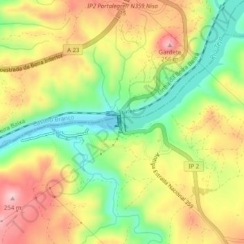
Name: Barragem de Fratel topographic map, elevation, terrain.
Average elevation: 489 ft
Minimum elevation: 161 ft
Maximum elevation: 823 ft
Other topographic maps
Click on a map to view its topography, its elevation and its terrain.
Amieira do Tejo
Portugal > Portalegre > Arez e Amieira do Tejo > Amieira do Tejo
Amieira do Tejo, Arez e Amieira do Tejo, Nisa, Portalegre, Portugal
Average elevation: 745 ft