
Make a donation
Gear up for your next adventure:
As an Amazon Associate, this site earns from qualifying purchases at no extra cost to you.
Kohler topographic map
Click on the map to display elevation.
Make a donation
Gear up for your next adventure:
As an Amazon Associate, this site earns from qualifying purchases at no extra cost to you.
About this map
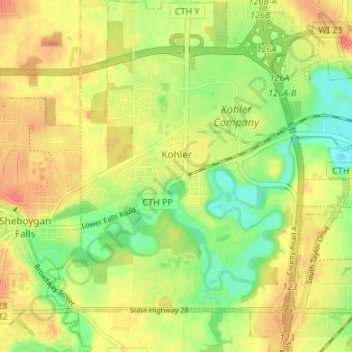
Name: Kohler topographic map, elevation, terrain.
Location: Kohler, Sheboygan County, Wisconsin, 53044, United States (43.71187 -87.80448 43.76036 -87.74943)
Average elevation: 673 ft
Minimum elevation: 584 ft
Maximum elevation: 748 ft
Sheboygan County trails, hiking, mountain biking, running and outdoor activities
Make a donation
Gear up for your next adventure:
As an Amazon Associate, this site earns from qualifying purchases at no extra cost to you.
Other topographic maps
Click on a map to view its topography, its elevation and its terrain.
Sheboygan Marsh 2 WP 319 Dam
United States > Wisconsin > Sheboygan County > Town of Russell
Average elevation: 932 ft