
Nugegoda topographic map
Interactive map
Click on the map to display elevation.
About this map
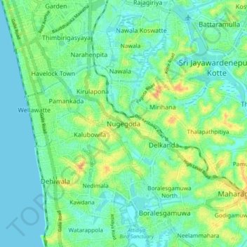
Name: Nugegoda topographic map, elevation, terrain.
Location: Nugegoda, Colombo District, Western Province, 10250, Sri Lanka (6.82997 79.84828 6.90997 79.92828)
Average elevation: 36 ft
Minimum elevation: -7 ft
Maximum elevation: 108 ft
Other topographic maps
Click on a map to view its topography, its elevation and its terrain.
Balapokuna
Sri Lanka > Western Province > Nugegoda
Balapokuna, Nugegoda, Colombo District, Western Province, 10250, Sri Lanka
Average elevation: 49 ft