
Hendek topographic map
Interactive map
Click on the map to display elevation.
About this map
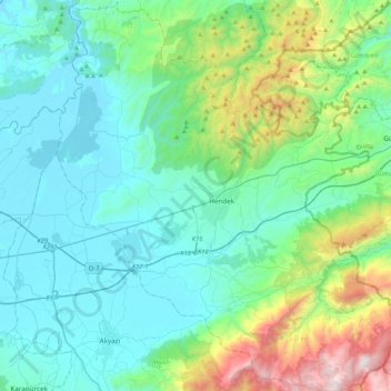
Name: Hendek topographic map, elevation, terrain.
Location: Hendek, Sakarya, Marmara Region, Turkey (40.63987 30.56703 40.95869 30.94149)
Average elevation: 1,122 ft
Minimum elevation: 43 ft
Maximum elevation: 5,656 ft
Other topographic maps
Click on a map to view its topography, its elevation and its terrain.
Rasimpaşa Mahallesi
Turkey > Hendek > Rasimpaşa Mahallesi
Rasimpaşa Mahallesi, Hendek, Sakarya, Marmara Region, Turkey
Average elevation: 541 ft