Geolocate

Prairie Ridge topographic map

Click on the map to display elevation.

About this map

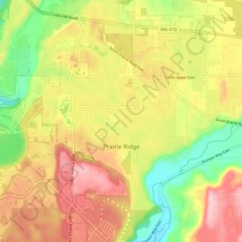
Name: Prairie Ridge topographic map, elevation, terrain.

Location: Prairie Ridge, Pierce County, Washington, United States (47.12038 -122.17422 47.16607 -122.09672)

Average elevation: 646 ft

Minimum elevation: 312 ft

Maximum elevation: 1,010 ft

Pierce County trails, hiking, mountain biking, running and outdoor activities

Gear up for your next adventure:

🧤Tactile Hiking Gloves - Keep hands warm while operating GPS and smartphone screens
🏕️Tent Footprint - Protect your tent base from wear
🧦Merino Wool Socks - Moisture-wicking, blister-preventing socks for long treks
🔋Rechargeable Batteries - Power up your outdoor devices
🛠️Backpacking Tool Kit - Essential toolkit for outdoor repairs

As an Amazon Associate, this site earns from qualifying purchases at no extra cost to you.