
Thank you for supporting this site ❤️
Make a donation
Make a donation
Gear up for your next adventure:
As an Amazon Associate, this site earns from qualifying purchases at no extra cost to you.
Medelim topographic map
Click on the map to display elevation.
Thank you for supporting this site ❤️
Make a donation
Make a donation
Gear up for your next adventure:
As an Amazon Associate, this site earns from qualifying purchases at no extra cost to you.
About this map
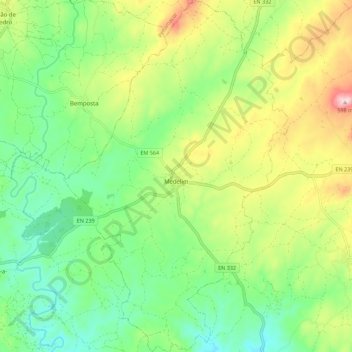
Name: Medelim topographic map, elevation, terrain.
Location: Medelim, Idanha-a-Nova, Castelo Branco, Portugal (40.00715 -7.21858 40.09244 -7.14720)
Average elevation: 1,296 ft
Minimum elevation: 942 ft
Maximum elevation: 1,919 ft
Thank you for supporting this site ❤️
Make a donation
Make a donation
Gear up for your next adventure:
As an Amazon Associate, this site earns from qualifying purchases at no extra cost to you.
Other topographic maps
Click on a map to view its topography, its elevation and its terrain.
Inselberg de Monsanto
Portugal > Castelo Branco > Idanha-a-Nova > Adingeiro
Average elevation: 1,591 ft