
Thank you for supporting this site ❤️
Make a donation
Make a donation
Gear up for your next adventure:
As an Amazon Associate, this site earns from qualifying purchases at no extra cost to you.
Anniviers topographic map
Click on the map to display elevation.
Thank you for supporting this site ❤️
Make a donation
Make a donation
Gear up for your next adventure:
As an Amazon Associate, this site earns from qualifying purchases at no extra cost to you.
About this map
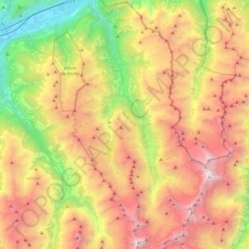
Name: Anniviers topographic map, elevation, terrain.
Location: Anniviers, Sierre, Wallis, 3961, Switzerland (46.02733 7.51513 46.27971 7.71614)
Average elevation: 7,579 ft
Minimum elevation: 1,611 ft
Maximum elevation: 14,596 ft
Thank you for supporting this site ❤️
Make a donation
Make a donation
Gear up for your next adventure:
As an Amazon Associate, this site earns from qualifying purchases at no extra cost to you.