
Thank you for supporting this site ❤️
Make a donation
Make a donation
Gear up for your next adventure:
As an Amazon Associate, this site earns from qualifying purchases at no extra cost to you.
Michendorf topographic map
Click on the map to display elevation.
Thank you for supporting this site ❤️
Make a donation
Make a donation
Gear up for your next adventure:
As an Amazon Associate, this site earns from qualifying purchases at no extra cost to you.
About this map
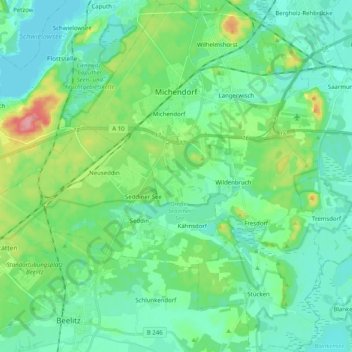
Name: Michendorf topographic map, elevation, terrain.
Location: Michendorf, Potsdam-Mittelmark, Brandenburg, 14552, Germany (52.22534 12.96701 52.34851 13.11580)
Average elevation: 157 ft
Minimum elevation: 85 ft
Maximum elevation: 400 ft
Thank you for supporting this site ❤️
Make a donation
Make a donation
Gear up for your next adventure:
As an Amazon Associate, this site earns from qualifying purchases at no extra cost to you.