
Ανδρίτσαινα topographic map
Interactive map
Click on the map to display elevation.
About this map
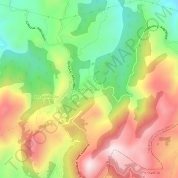
Name: Ανδρίτσαινα topographic map, elevation, terrain.
Average elevation: 2,736 ft
Minimum elevation: 1,578 ft
Maximum elevation: 4,006 ft
Other topographic maps
Click on a map to view its topography, its elevation and its terrain.
Pyrgos
Griechenland > Peloponnes, Westgriechenland und Ionische Inseln > Regionalbezirk Elis > Pyrgos
Pyrgos, Regionalbezirk Elis, Region Westgriechenland, Peloponnes, Westgriechenland und Ionische Inseln, Griechenland
Average elevation: 253 ft
Antikes Olympia
Griechenland > Peloponnes, Westgriechenland und Ionische Inseln > Regionalbezirk Elis
Antikes Olympia, Δήμος Αρχαίας Ολυμπίας, Regionalbezirk Elis, Region Westgriechenland, Peloponnes, Westgriechenland und Ionische Inseln, 270 65, Griechenland
Average elevation: 325 ft