
Make a donation
Gear up for your next adventure:
As an Amazon Associate, this site earns from qualifying purchases at no extra cost to you.
Itacaré topographic map
Click on the map to display elevation.
Make a donation
Gear up for your next adventure:
As an Amazon Associate, this site earns from qualifying purchases at no extra cost to you.
About this map
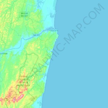
Name: Itacaré topographic map, elevation, terrain.
Average elevation: 141 ft
Minimum elevation: -13 ft
Maximum elevation: 1,332 ft
Make a donation
Gear up for your next adventure:
As an Amazon Associate, this site earns from qualifying purchases at no extra cost to you.
Other topographic maps
Click on a map to view its topography, its elevation and its terrain.
Picado
Brazil > Bahia > Região Metropolitana de Feira de Santana > Conceição do Jacuípe
Average elevation: 617 ft
Fazenda Vargem Grande
Brazil > Bahia > Bom Jesus da Lapa > Fazenda Vargem Grande
Average elevation: 1,401 ft
Make a donation
Gear up for your next adventure:
As an Amazon Associate, this site earns from qualifying purchases at no extra cost to you.