
Thank you for supporting this site ❤️
Make a donation
Make a donation
Gear up for your next adventure:
As an Amazon Associate, this site earns from qualifying purchases at no extra cost to you.
Sint-Laureins topographic map
Click on the map to display elevation.
Thank you for supporting this site ❤️
Make a donation
Make a donation
Gear up for your next adventure:
As an Amazon Associate, this site earns from qualifying purchases at no extra cost to you.
About this map
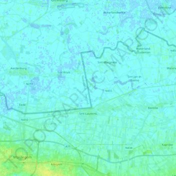
Name: Sint-Laureins topographic map, elevation, terrain.
Location: Sint-Laureins, Eeklo, East Flanders, Flanders, Belgium (51.21552 3.47574 51.30595 3.68700)
Average elevation: 7 ft
Minimum elevation: -10 ft
Maximum elevation: 49 ft
Thank you for supporting this site ❤️
Make a donation
Make a donation
Gear up for your next adventure:
As an Amazon Associate, this site earns from qualifying purchases at no extra cost to you.