
Vila Chã topographic map
Interactive map
Click on the map to display elevation.
About this map
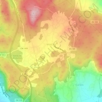
Name: Vila Chã topographic map, elevation, terrain.
Location: Vila Chã, Esposende, Braga, Portugal (41.55230 -8.77434 41.58759 -8.73014)
Average elevation: 551 ft
Minimum elevation: 112 ft
Maximum elevation: 889 ft
Other topographic maps
Click on a map to view its topography, its elevation and its terrain.
Praia de Ofir
Praia de Ofir, Apúlia e Fão, Esposende, Braga, Portugal
Average elevation: 7 ft
Praia das Pedrinhas
Praia das Pedrinhas, Apúlia e Fão, Esposende, Braga, 4740-055, Portugal
Average elevation: 13 ft
Praia Suave Mar (Norte)
Praia Suave Mar (Norte), Cepães, Esposende, Marinhas e Gandra, Esposende, Braga, Portugal
Average elevation: 16 ft
Palmeira de Faro
Palmeira de Faro, Palmeira de Faro e Curvos, Esposende, Braga, Portugal
Average elevation: 236 ft