
Gunjur topographic map
Interactive map
Click on the map to display elevation.
About this map
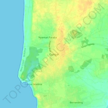
Name: Gunjur topographic map, elevation, terrain.
Location: Gunjur, Brikama, West Coast Division, The Gambia (13.13602 -16.79990 13.21602 -16.71990)
Average elevation: 33 ft
Minimum elevation: 0 ft
Maximum elevation: 82 ft
Other topographic maps
Click on a map to view its topography, its elevation and its terrain.
Kartong
The Gambia > West Coast Division > Kartong
Kartong, Brikama, West Coast Division, The Gambia
Average elevation: 10 ft
Seawall
The Gambia > West Coast Division > Seawall
Seawall, Brikama, West Coast Division, The Gambia
Average elevation: 102 ft