
Canoas topographic map
Click on the map to display elevation.
Canoas
Canoas is an industrial and educational hub, drawing residents from surrounding municipalities. It hosts a campus of the Federal Institute of Rio Grande do Sul and several universities including Ulbra, UniRitter, Universidade La Salle, and IPUC. The city is positioned at an elevation of eight meters above sea level, and is distinguished by the Gravataí and Sinos rivers that traverse its landscape.
About this map
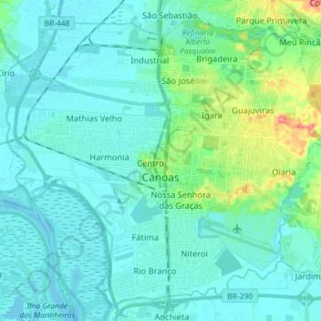
Name: Canoas topographic map, elevation, terrain.
Average elevation: 39 ft
Minimum elevation: -3 ft
Maximum elevation: 233 ft
Other topographic maps
Click on a map to view its topography, its elevation and its terrain.
Porto Alegre
Brazil > Rio Grande do Sul > Metropolitan Region of Porto Alegre > Porto Alegre
Porto Alegre has a long coastline on the Guaíba Lake, and its topography is punctuated by 40 hills. In the lake, a vast body of water, a maze of islands facing the city creates an archipelago where a unique ecosystem gives shelter to abundant wildlife. The city area concentrates 28% of the native flora of Rio…
Average elevation: 89 ft
Estrada Carlos Dreyer
Brazil > Rio Grande do Sul > Metropolitan Region of Porto Alegre > Igrejinha
Average elevation: 2,041 ft