
Mysuru topographic map
Click on the map to display elevation.
Mysuru
Mysore is situated at the foothills of the Chamundi Hills. At an altitude of 770 m (2,530 ft) above mean sea level, the city of Mysore is geographically located at 12° 18′ 26″ north latitude and 76° 38′ 59″ east longitude. It is about 140 km (87.0 mi) southwest of the state's capital, Bangalore, and spreads across an area of 156 km2 (60 sq mi) (city and neighbouring census towns). The population of the city combined with its neighbouring towns in its metropolitan area is about 1,288,000 in 2023.
About this map
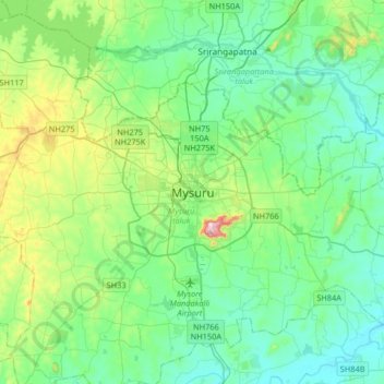
Name: Mysuru topographic map, elevation, terrain.
Average elevation: 2,385 ft
Minimum elevation: 2,100 ft
Maximum elevation: 3,438 ft
Other topographic maps
Click on a map to view its topography, its elevation and its terrain.
Mysuru
India > Karnataka > Mysuru taluk > Mysuru
Mysore is situated at the foothills of the Chamundi Hills. At an altitude of 770 m (2,530 ft) above mean sea level, the city of Mysore is geographically located at 12° 18′ 26″ north latitude and 76° 38′ 59″ east longitude. It is about 140 km (87.0 mi) southwest of the state's capital, Bangalore, and…
Average elevation: 2,467 ft