
Orte topographic map
Interactive map
Click on the map to display elevation.
About this map
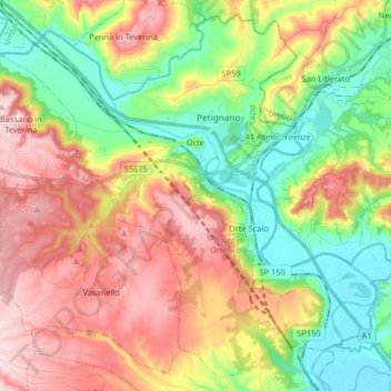
Name: Orte topographic map, elevation, terrain.
Location: Orte, Viterbo, Latium, Italien (42.38841 12.30520 42.49996 12.46761)
Average elevation: 554 ft
Minimum elevation: 125 ft
Maximum elevation: 1,089 ft
Other topographic maps
Click on a map to view its topography, its elevation and its terrain.
Capodimonte
Capodimonte, Viterbo, Latium, Italien
Average elevation: 1,122 ft
Oriolo Romano
Oriolo Romano, Viterbo, Latium, Italien
Average elevation: 1,358 ft
Monte Romano
Monte Romano, Viterbo, Latium, Italien
Average elevation: 522 ft
Montalto di Castro
Montalto di Castro, Viterbo, Latium, 01014, Italien
Average elevation: 157 ft