
Neustadt an der Weinstraße topographic map
Interactive map
Click on the map to display elevation.
About this map
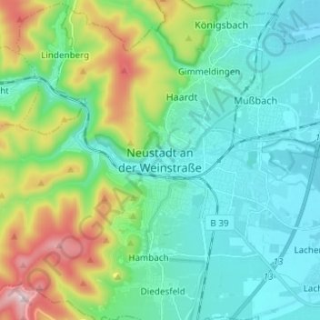
Name: Neustadt an der Weinstraße topographic map, elevation, terrain.
Location: Neustadt an der Weinstraße, Rhineland-Palatinate, 67433, Germany (49.31398 8.09500 49.39398 8.17500)
Average elevation: 823 ft
Minimum elevation: 381 ft
Maximum elevation: 2,201 ft
Other topographic maps
Click on a map to view its topography, its elevation and its terrain.
Neustadt an der Weinstraße
Germany > Rhineland-Palatinate > Neustadt an der Weinstraße
Neustadt an der Weinstraße, Rhineland-Palatinate, Germany
Average elevation: 820 ft