
Carcastillo topographic map
Interactive map
Click on the map to display elevation.
About this map
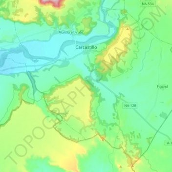
Name: Carcastillo topographic map, elevation, terrain.
Location: Carcastillo, Navarra, 31310, España (42.29263 -1.50119 42.40968 -1.32908)
Average elevation: 1,309 ft
Minimum elevation: 1,056 ft
Maximum elevation: 2,073 ft
Other topographic maps
Click on a map to view its topography, its elevation and its terrain.
Laguna Dos Reinos
España > Navarra > Carcastillo
Laguna Dos Reinos, Carretera de Figarol, Carcastillo, Navarra, España
Average elevation: 1,237 ft