Geolocate

Carbonne topographic map

Click on the map to display elevation.

About this map
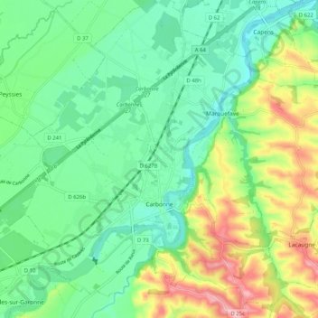
Name: Carbonne topographic map, elevation, terrain.

Location: Carbonne, Muret, Haute-Garonne, Occitania, Metropolitan France, 31390, France (43.26919 1.18182 43.34337 1.28241)

Average elevation: 761 ft

Minimum elevation: 584 ft

Maximum elevation: 1,129 ft

Other topographic maps

Click on a map to view its topography, its elevation and its terrain.
Toulouse

France > Occitania > Haute-Garonne > Toulouse

Average elevation: 568 ft

Grand-Noble

France > Occitania > Haute-Garonne > Blagnac

Average elevation: 463 ft

Gear up for your next adventure:

🪶Fire Starter Kit - Reliable fire starter for survival and camping
🌄Hiking Binoculars - Compact binoculars for scenic views and trail spotting
🪵Folding Camp Saw - Compact saw for wood and campsite work
📚USA Hiking Guide Books - Top trail guides and map books
☀️Outdoor Sunscreen - High protection sunscreen for outdoor activities

As an Amazon Associate, this site earns from qualifying purchases at no extra cost to you.