
Make a donation
Gear up for your next adventure:
As an Amazon Associate, this site earns from qualifying purchases at no extra cost to you.
Querétaro topographic map
Click on the map to display elevation.
Make a donation
Gear up for your next adventure:
As an Amazon Associate, this site earns from qualifying purchases at no extra cost to you.
Querétaro
The municipality has rolling hills, mountain ranges and flatlands. Most of the rolling hills cross the territory from south to north, paralleling the Querétaro-San Luis Potosí highway. Most plains are located in the north, and are of sedimentary soil with some protrusions of volcanic rock. Altitude varies from 1,900 to 2,460 meters above sea level with the highest elevations at mountains called El Buey, Pie de Gallo, El Patol, El Nabo, and El Paisano. The city proper is on a plain at 1,900 meters. There is only one river, the Querétaro River, which carved the La Cañada. There are numerous streams, many of them seasonal, and fresh water springs near the mountain areas. The territory contains deposits of gold, silver, manganese, tin, mercury, lead, zinc, opal, quartz, cantera stone (for building) among other minerals.
Make a donation
Gear up for your next adventure:
As an Amazon Associate, this site earns from qualifying purchases at no extra cost to you.
About this map
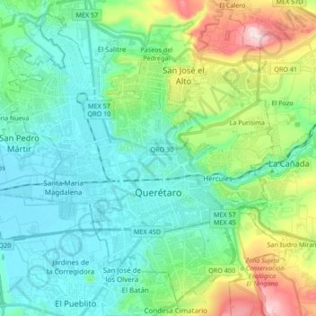
Name: Querétaro topographic map, elevation, terrain.
Location: Querétaro, Municipio de Querétaro, Querétaro, Mexico (20.54031 -100.48015 20.68397 -100.31196)
Average elevation: 6,302 ft
Minimum elevation: 5,889 ft
Maximum elevation: 7,598 ft
Make a donation
Gear up for your next adventure:
As an Amazon Associate, this site earns from qualifying purchases at no extra cost to you.
Other topographic maps
Click on a map to view its topography, its elevation and its terrain.
Parque Queretaro 2000
Mexico > Querétaro > Municipio de Querétaro > Querétaro
Average elevation: 6,079 ft