
Isar topographic map
Click on the map to display elevation.
About this map
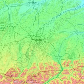
Name: Isar topographic map, elevation, terrain.
Location: Isar, Germany (47.37373 11.25558 48.80368 12.97832)
Average elevation: 2,195 ft
Minimum elevation: 1,083 ft
Maximum elevation: 9,236 ft
Other topographic maps
Click on a map to view its topography, its elevation and its terrain.
Nabern
Germany > Baden-Württemberg > Landkreis Esslingen > Kirchheim unter Teck
Average elevation: 1,263 ft
Lehnberg
Germany > Thuringia > Landkreis Nordhausen > Harztor > Herrmannsacker
Average elevation: 1,332 ft
Niels
Germany > Mecklenburg-Vorpommern > Ludwigslust-Parchim > Bresegard bei Picher
Average elevation: 66 ft
Kierdorf
Germany > North Rhine-Westphalia > Rheinisch-Bergischer Kreis > Bergisch Gladbach > Herkenrath
Average elevation: 620 ft
Ginsburg
Germany > North Rhine – Westphalia > Kreis Siegen-Wittgenstein > Hilchenbach
The town's largest flowing body of water is the Ferndorfbach, a tributary to the river Sieg. The municipal area's average elevation is 427 metres (1,401 ft) above sea level, with its highest elevation being at 678 metres (2,224 ft) at the Riemen, a peak in the Rothaargebirge.
Average elevation: 1,673 ft
Sauerland
Germany > North Rhine – Westphalia
To the west the hills continue into the Bergisches Land, to the south into the Siegerland, and to the north-east into the Teutoburg Forest. The major rivers of the Sauerland are the Ruhr and the Lenne. Several artificial lakes were created on the smaller rivers by building dams to store water for the nearby…
Average elevation: 1,037 ft
Klein Bengerstorf
Germany > Mecklenburg-Vorpommern > Ludwigslust-Parchim > Bengerstorf
Average elevation: 79 ft
Lohe
Germany > Lower Saxony > Landkreis Cuxhaven > Hagen im Bremischen > Lohe
Average elevation: 43 ft
Hanover
Germany > Lower Saxony > Region Hannover > Hanover
In 1636 George, Duke of Brunswick-Lüneburg, ruler of the Brunswick-Lüneburg principality of Calenberg, moved his residence to Hanover. The Dukes of Brunswick-Lüneburg were elevated by the Holy Roman Emperor to the rank of Prince-Elector in 1692 and this elevation was confirmed by the Imperial Diet in 1708.…
Average elevation: 230 ft
Kleinberg
Germany > Bavaria > Landkreis Neustadt an der Waldnaab > Kirchendemenreuth
Average elevation: 1,545 ft
Tromsdorf
Germany > Saxony-Anhalt > Burgenlandkreis > Eckartsberga > Tromsdorf
Average elevation: 640 ft
NSG Wiesen am Hirtenborn
Germany > Rhineland-Palatinate > Landkreis Mainz-Bingen > Manubach
Average elevation: 1,467 ft
Markt Schwaben
Germany > Bavaria > Landkreis Ebersberg > Markt Schwaben > Markt Schwaben
Average elevation: 1,683 ft