
Thank you for supporting this site ❤️
Make a donation
Make a donation
Gear up for your next adventure:
As an Amazon Associate, this site earns from qualifying purchases at no extra cost to you.
Al-Fashir topographic map
Click on the map to display elevation.
Thank you for supporting this site ❤️
Make a donation
Make a donation
Gear up for your next adventure:
As an Amazon Associate, this site earns from qualifying purchases at no extra cost to you.
About this map
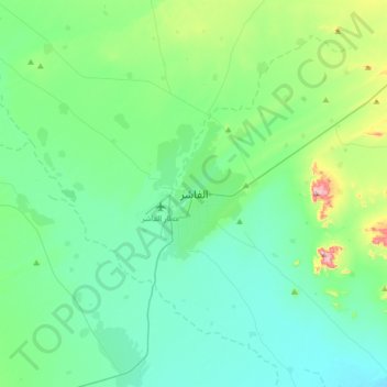
Name: Al-Fashir topographic map, elevation, terrain.
Location: Al-Fashir, Al Fasher, North Darfur State, Sudan (13.46382 25.19556 13.78382 25.51556)
Average elevation: 2,470 ft
Minimum elevation: 2,244 ft
Maximum elevation: 3,474 ft
Thank you for supporting this site ❤️
Make a donation
Make a donation
Gear up for your next adventure:
As an Amazon Associate, this site earns from qualifying purchases at no extra cost to you.