Geolocate

La Rinconada topographic map

Click on the map to display elevation.

La Rinconada

The town has gained notoriety for its extreme living conditions that include its high rates of altitude sickness, pollution, poverty, murder, and sex trafficking, and as a result has sometimes been referred to in Spanish as la ciudad sin ley del Perú, which means "the lawless city of Peru".

Wikipedia (CC-BY-SA 3.0)

About this map

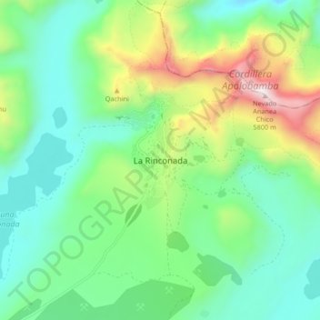
Name: La Rinconada topographic map, elevation, terrain.

Location: La Rinconada, Ananea, Province of San Antonio de Putina, Puno, Peru (-14.67416 -69.48688 -14.59416 -69.40688)

Average elevation: 16,152 ft

Minimum elevation: 14,928 ft

Maximum elevation: 19,140 ft

Gear up for your next adventure:

🧭GPS Watch Accessories - Bands and chargers for GPS watches
🌲Outdoor Survival Books - Best books on survival skills
📡GPS Antenna Upgrade - Enhance GPS reception in remote terrain
🧴Hand Sanitizer - Keep hands clean while hiking
👖Convertible Hiking Pants - Versatile zip-off pants for changing altitudes and temperatures

As an Amazon Associate, this site earns from qualifying purchases at no extra cost to you.