Geolocate

Chillicothe topographic map

Click on the map to display elevation.

About this map

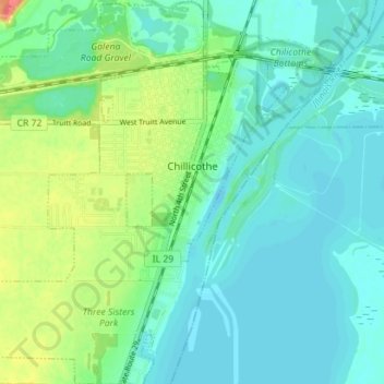
Name: Chillicothe topographic map, elevation, terrain.

Location: Chillicothe, Peoria County, Illinois, 61523, United States (40.88579 -89.53411 40.93908 -89.47120)

Average elevation: 479 ft

Minimum elevation: 433 ft

Maximum elevation: 610 ft

Peoria County trails, hiking, mountain biking, running and outdoor activities

Other topographic maps

Click on a map to view its topography, its elevation and its terrain.

Monica

United States > Illinois > Peoria County

Average elevation: 755 ft

Kickapoo

United States > Illinois > Peoria County

Average elevation: 650 ft

Trivoli

United States > Illinois > Peoria County

Average elevation: 735 ft

Peoria

United States > Illinois > Peoria County > Peoria

Average elevation: 643 ft

Gear up for your next adventure:

Backpacking Tent - Lightweight and durable tent for multi‑day hikes
🧢Outdoor Hiking Hat - Sun protection hat for outdoor explorers
🥄Camping Utensil Set - Lightweight utensils for outdoor meals
🛠️Outdoor Gear Repair Kit - Essential tools to fix gear on the trail
🧭Compass with Lanyard - Easy‑carry compass for navigation

As an Amazon Associate, this site earns from qualifying purchases at no extra cost to you.