Geolocate

Kamuning topographic map

Click on the map to display elevation.

About this map

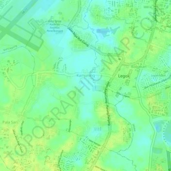
Name: Kamuning topographic map, elevation, terrain.

Location: Kamuning, Legok, Tangerang Regency, Java, Indonesia (-6.31239 106.57227 -6.29115 106.59005)

Average elevation: 141 ft

Minimum elevation: 108 ft

Maximum elevation: 167 ft

Other topographic maps

Click on a map to view its topography, its elevation and its terrain.

Taban

Indonesia > Tangerang Regency

Average elevation: 144 ft

Kohod

Indonesia > Tangerang Regency

Average elevation: 7 ft

Suka Harja

Indonesia > Tangerang Regency

Average elevation: 69 ft

Gear up for your next adventure:

📚Navigation Handbooks - Master the art of reading topographic maps and using a compass
📌Outdoor GPS Map App - Apps and devices for digital topographic navigation
🪶Trail Camera - Capture wildlife on your hikes
🛏️Cold Weather Sleeping Bag - Warm sleeping bag for cold conditions
🔦Powerful Headlamps - Ultra-bright hands-free lighting for night navigation

As an Amazon Associate, this site earns from qualifying purchases at no extra cost to you.