Geolocate

Sampaga topographic map

Click on the map to display elevation.

About this map
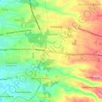
Name: Sampaga topographic map, elevation, terrain.

Location: Sampaga, Batangas City, Batangas, Calabarzon, 4200, Philippines (13.73599 121.08410 13.77599 121.12410)

Average elevation: 213 ft

Minimum elevation: 39 ft

Maximum elevation: 390 ft

Other topographic maps

Click on a map to view its topography, its elevation and its terrain.
Santa Clara

Philippines > Batangas > Batangas City

Average elevation: 16 ft

Verde Island

Philippines > Batangas > Batangas City

Average elevation: 171 ft

Kumintang Ilaya

Philippines > Batangas > Batangas City

Average elevation: 121 ft

Balete

Philippines > Batangas > Batangas City

Average elevation: 476 ft

Malalim

Philippines > Batangas > Batangas City

Average elevation: 174 ft

Bucal

Philippines > Batangas > Batangas City

Average elevation: 476 ft

Concepcion

Philippines > Batangas > Batangas City

Average elevation: 486 ft

Pallocan West

Philippines > Batangas > Batangas City

Average elevation: 52 ft

Gear up for your next adventure:

☀️Outdoor Sunscreen - High protection sunscreen for outdoor activities
🧭Compass with Lanyard - Easy‑carry compass for navigation
📶Vehicle Signal Boosters - Improve reception in rural areas while driving to trailheads
📷Action Cameras - Rugged cameras to document your journeys across rugged terrain
🛡️Insect Repellent - Protection against bugs during outdoor activities

As an Amazon Associate, this site earns from qualifying purchases at no extra cost to you.