Geolocate

Bautzen topographic map

Click on the map to display elevation.

About this map

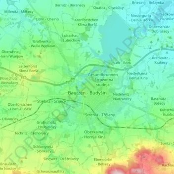
Name: Bautzen topographic map, elevation, terrain.

Location: Bautzen, Bautzen - Budyšin, Saxony, 02625, Germany (51.13727 14.32407 51.23207 14.49264)

Average elevation: 689 ft

Minimum elevation: 469 ft

Maximum elevation: 1,394 ft

Other topographic maps

Click on a map to view its topography, its elevation and its terrain.

Hermsdorf

Germany > Saxony > Bautzen - Budyšin > Ottendorf-Okrilla

Average elevation: 607 ft

Leppersdorf

Germany > Saxony > Bautzen - Budyšin

Average elevation: 889 ft

Gaußig - Huska

Germany > Saxony > Bautzen - Budyšin

Average elevation: 876 ft

Baruth - Bart

Germany > Saxony > Bautzen - Budyšin

Average elevation: 515 ft

Ostro - Wotrow

Germany > Saxony > Bautzen - Budyšin

Average elevation: 702 ft

Taschendorf

Germany > Saxony > Bautzen - Budyšin

Average elevation: 837 ft

Sdier - Zdźěr

Germany > Saxony > Bautzen - Budyšin

Average elevation: 509 ft

Kalte Ruhe

Germany > Saxony > Bautzen - Budyšin > Radeberg

Average elevation: 833 ft

Wessel - Wjesel

Germany > Saxony > Bautzen - Budyšin

Average elevation: 449 ft

Gear up for your next adventure:

🦶Hiking Gaiters - Keep debris and water out of your boots
🛏️Cold Weather Sleeping Bag - Warm sleeping bag for cold conditions
🗻Climbing Gear Basics - Essential gear for beginner climbers
Camping Coffee Makers - Enjoy premium coffee at the summit or campsite
🪶Thermal Camp Blanket - Extra warmth for cold nights

As an Amazon Associate, this site earns from qualifying purchases at no extra cost to you.