
Make a donation
Gear up for your next adventure:
As an Amazon Associate, this site earns from qualifying purchases at no extra cost to you.
Pezinok topographic map
Click on the map to display elevation.
Make a donation
Gear up for your next adventure:
As an Amazon Associate, this site earns from qualifying purchases at no extra cost to you.
Pezinok
Pezinok lies at an altitude of 152 metres (499 ft) above sea level and covers an area of 72.555 square kilometres (28.0 sq mi). It is located in the Danubian Lowland at the foothills of the Little Carpathians, around 20 km (12.43 mi) north-east of Bratislava. Another major city, Trnava, is located around 25 km (15.53 mi) to the east.
Make a donation
Gear up for your next adventure:
As an Amazon Associate, this site earns from qualifying purchases at no extra cost to you.
About this map
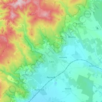
Name: Pezinok topographic map, elevation, terrain.
Location: Pezinok, District of Pezinok, Region of Bratislava, Slovakia (48.25495 17.15309 48.38155 17.31548)
Average elevation: 984 ft
Minimum elevation: 423 ft
Maximum elevation: 2,454 ft
Make a donation
Gear up for your next adventure:
As an Amazon Associate, this site earns from qualifying purchases at no extra cost to you.
Other topographic maps
Click on a map to view its topography, its elevation and its terrain.
Častá
Slovakia > Region of Bratislava > District of Pezinok
The village lies at an altitude of 245 meters and covers an area of 35.24 km². It has population of 2,078 people.
Average elevation: 860 ft